The Port Authority of Valencia (PAV) opens the procedure of public information on the offer of the Levante UD.
After the publication in the BOE, a period of 20 calendar days will be opened for the submission of submissions to the project.
This project is part of the Special Plan of the South Zone of the Port of Valencia, known as the Port Plan for Natzaret”. A plan that has allowed 230.000 square meters of land owned by the port (publicly owned land) to be used for parks, gardens, sports areas and training and tertiary use centers.
Valencia, February the 26th of 2019.- The Port Authority of Valencia (PAV) has begun the process of public information of the request submitted by the ‘Levante Unión Deportiva’, SAD for the concession of a plot of 94,999.66 m2 located in the Natzaret area, for the construction and operation of a sports facility. The exit of this project to public information occurs after completing the process of competition of projects without having received any other request for this space. The PAV has already submitted the Levante Unión Deportiva project for publication in the Official State Gazette (BOE), which will open – starting the day after its publication – a period of 20 days for the presentation of allegations. The work in the area will begin after responding to these allegations.
From the PAV it has been pointed out that “the fact that a sports institution like the Levante UD chooses to install its soccer city on the land that the port has enabled for sports areas in front of the Natzaret neighborhood, is a great opportunity for the residents of València capital and, especially, for the neighborhoods sailors. It is a project that will be a great social and economic revulsive for the area, an urban area adjacent to the port of Valencia that, from now on, will benefit from the synergies and the projection of an activity that will result in improvements in the social and economic life of the neighborhood”.
The sports area that will occupy Levante UD is part of the Special Plan of the South Zone of the Port of Valencia (Port Plan for Natzaret) which occupies 230,000 m2. It is a surface that the Port Authority of Valencia has decided to allocate to the use and enjoyment of citizens and shows the excellent relations it has with the Valencia City Council.
All the information about the Levante UD project in this area can be consulted on the Levante UD website: http://www.levanteud.com/es/info/el-levante-ud-presenta-el-proyecto-basico-de-la-nueva-ciudad-deportiva-de-nazaret
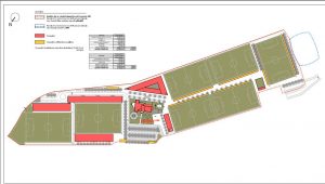
Special plan east Natzaret
The Port Plan for Natzaret approved by the Administration Council of the PAV establishes the conditions of use and plot and building of the delimitation areas that include:
- Area 1, Turia Mouth Park: 86,296.08 m2
Configured downstream from the Bridge of Shipyards, includes the new park of structural management and the old bed of the Turia, now channeled, with a total area of 86,296.08 m2. The design will incorporate the requirement to extend Sech street, with a minimum width of 10 meters, urbanized as an internal pedestrian path of the park with a path parallel to the delimitation defined between the proposed areas 1 and 3.
Area 2, Tertiary Use: 18,454.04 m2
Located approximately on the site of the old facilities of ARLESA (later MOYRESA, and in its last stage also known as BUNGE) it is intended for tertiary use, and in its case also dotational, with an extension of 18,454.04 m2. The tertiary and multi-functional area is integrated into the urban fabric of Nazareth and falls into the Mouth Park of the Turia Garden.
In relation to the building, a buildable volume is proposed capable of housing the 25,000 m2t foreseen in the agreement, with the following plot and volumetric arrangement:
- 3 rectangular blocks of maximum depth of 18 meters and 5 floors of maximum height, arranged so that their longitudinal development is parallel to the alignment of the interior free space that collects current planning and that is coincident with the direction of the Castell de Pop street in the final stretch between Mascarat street and Sech street.
- At the northeast edge, a curved guide block is proposed, coinciding with the perimeter road layout, which is planned with a variable width that ranges between 20 m and 13.9 m and with a maximum height of 7 heights.
It is guaranteed that the buildable volumes are located perpendicular to the alignment of the new outlet Park and the visual permeability and routes from the consolidated Nazareth plot are maximized.
Area 3, sports facilities: 98,940.17 m2
Sports and free space area of an area of 98,940.17 m2. This sports equipment partially occupies the existing green area to the south (Natzaret south park) and represents the recovery of the site of a sporting endowment, a green border between the port activity and the Nazareth district, and a dynamic center of uses and activities linked to leisure and sports.
The planning orders this area, a priori, in two differentiated urban plots in order to facilitate its management and subsequent execution:
- A first plot that occupies practically the entire scope of the area, with a floor area of 94,999.66 m2 whose main destination will be to host outdoor sports facilities. It provides the possibility of locating buildings linked to the main use, as well as other auxiliary constructions of support. In the plot of use ZV-DP (p3.1) is located the property protected by the general planning, “Benimar” building, which is included in the Inventory of joint buildings and architectural interest elements of the municipality of Valencia. The planned sports equipment that includes this area must execute the rehabilitation works of the Benimar building.
- The second plot has an area of 3,940 m2 to locate a covered sports equipment.
Area 4, Marblau equipment: 2,246 m2
The planning of the plan incorporates the existing equipment located on Algemesí Street, currently in operation, managed by the City Council of Valencia through a use concession for youth center, popular university and garden museum in the old spa Marblau. The area destined to this area is 2,246 m2.
Area 5, South Nazareth Park: 8,375.86 m2
Area located on the southern edge of the area, with an extension of 8,375.86 m2. The criteria applied for this area seek to overcome the perception of the final stretch and the neighborhood of Nazareth. The ordination proposes two independent green areas and separated by a road that from the Algemesí street runs parallel to the southern exterior front of the covered sports facility to give access to a new parking area.
Green corridor
The Special Nazareth East Plan includes a cyclist and pedestrian green corridor that connects the Mouth Park with the current corridor that, running through the Logistics Activities Zone, comes to connect with the areas of Punta and Pinedo, with the aim of improving the continuity and the dimensions of the green corridor that surrounds Nazaret by the northeast, linking all the maritime towns from Malvarrosa to Punta and Pinedo. This bike lane will have a minimum width of 2.50 meters segregated from the road and the pedestrian area.