The project will provide the port area adjoining Nazaret with new green, tertiary and sports areas such as the Desembocadura Park or the Levante U.D. sports city
With this plan, the Port Authority of Valencia (PAV) will dedicate 230,000 square metres of port land for public use, equivalent to more than 40 football pitches
A further step for the city of Valencia, and especially the district of Nazaret, to have new spaces that reinforce the value of the area at the service of the citizens, such as the Parc de Desembocadura or the Levante U.D. Sports City. The Consell Jurídic Consultiu de la Comunitat Valenciana has given the go-ahead to the Special Plan for the South Zone 1 of the Port of Valencia, which will provide this area of the city with new green, tertiary and sports spaces, an action that will boost the economy of the area and the urban and social regeneration of the Nazaret neighbourhood.
This plan is of great importance for the relationship between the city of Valencia and its port, given that it contemplates the dedication for public use of an area of 230,000 square metres of port land equivalent to more than 40 football pitches.
The Plan has already been provisionally approved by the full City Council. Now, and after the approval of the Consell Jurídic Consultiu, the project will be seen in the previous informative session of the Territorial Commission of Urbanism, the last step before the signing and publication in the Official Gazette of the Generalitat Valenciana. It will be tomorrow when this informative commission will report on the project.
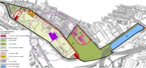
This Special Plan, which is part of the Port of Valencia’s Port Space Delimitation Document (DEUP), transfers and defines in detail the details of the specific agreement reached between Valencia City Council and the PAV, which was approved in February 2017. The Plan establishes the conditions of use and plot and building conditions of the development areas that are delimited and which include:
Area 1, Desembocadura del Turia Park: 86,296.08 m2
Configured downstream of the Astilleros Bridge, it includes the new structural development park and the old Turia riverbed, now channelled, with a total area of 86,296.08 m2.
Area 2, Tertiary Use: 18.454,04 m2
Located approximately on the site of the former ARLESA facilities (later MOYRESA, and in its last stage also known as BUNGE), it is intended for tertiary use, and if necessary also for public use, with an area of 18,454.04 m2. The whole of the tertiary and multi-purpose area is integrated into the urban fabric of Natzaret and falls within the Parque de Desembocadura del Jardín del Turia.
Area 3, Sports facilities: 98.940,17 m2
Sports and open space area of 98,940.17 m2. This sports facility partially occupies the existing green area to the south (Natzaret South Park) and represents the recovery of the site of a sports facility, a green border between the port activity and the Natzaret neighbourhood, and also a dynamic centre for uses and activities linked to leisure and sport.
The planning arranges this area, a priori, in two different urban plots in order to facilitate its management and subsequent execution:
A first plot that occupies practically the entire area, with a land area of 94,999.66 m2 whose main purpose will be to house outdoor sports facilities. It foresees the possibility of locating buildings linked to the main use, as well as other auxiliary support constructions. On the ZV-DP plot is located the building protected by the general planning, the “Benimar” building, which is included in the Inventory of buildings and elements of architectural interest of the municipality of Valencia. The sports facilities planned to be included in this area will have to carry out the refurbishment work on the Benimar building.
The second plot has a surface area of 3,940 m2 to locate an indoor sports facility.
Area 4, Marblau facilities: 2,246 m2
The plan incorporates the existing facility located in Algemesí Street, currently in operation, managed by the Valencia City Council through a concession for use as a youth centre, popular university and museum of the huerta in the old Marblau spa. The surface area allocated to this area is 2,246 m2.
Area 5, Natzaret South Park: 8.375,86 m2
Area located on the southern edge of the area, with an area of 8,375.86 m2. The criteria applied for this area seek to overcome the perception of the Natzaret neighbourhood as an enclosed final section. The planning proposes two independent green areas separated by a road that runs parallel to the southern exterior front of the covered sports facilities from Calle de Algemesí to give access to a new parking area.
Green corridor
The Plan includes a green cycling and pedestrian corridor linking the Desembocadura Park with the current corridor that, running through the Logistics Activities Zone, connects with the areas of La Punta and Pinedo, with the aim of improving the continuity and dimensions of the green corridor that runs around Nazaret to the northeast, linking all the maritime settlements from La Malvarrosa to La Punta and Pinedo. This cycle lane will have a minimum width of 2.50 metres, separated from the road and the pedestrian area.