The port authority of Valencia gives its approval to the Special Plan of the South Zone of the Port of Valencia (Natzaret East Plan) and agrees to transfer it to the València City Council for processing.
The plan, in which the PAV and the City Council of Valencia have worked together, establishes the conditions for the use of the areas destined for port-city integration in the Natzaret area.
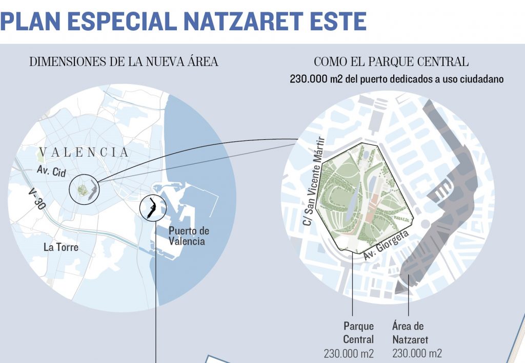
The port surface that the port will dedicate to citizen use is equivalent to the Central Park of València or to which it would occupy eight times the Valencia City Council square.
An Outfall Park with an area of 86,296.08 m2 will be created.
98,940.17 m2 will be allocated for sporting purposes between the neighborhood of Natzaret and the port.
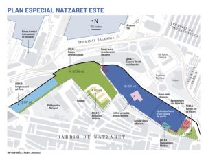
Valencia, January 10, 2019.- The Board of Directors of the Port Authority of Valencia (PAV), meeting in extraordinary session in the Clock Building, has given its approval to the Special Plan of the South Zone of the Port of Valencia (known Plan Natzaret) for which 230,000 square meters of port territory, adjacent to the Natzaret district, will be used for citizen use.
The surface area of this Special Plan of the Port of Valencia is equivalent to that occupied by the second most important park in València (the Central Park) and superior to that of the Viveros Garden (195,000 m2).
This Special Plan, which is part of the Port Space Delimitation Document (DEUP) of the Port of Valencia, translates and defines in detail the details of the specific agreement reached by the València City Council and the PAV that was approved in February 2017. The Board of Administration of the PAV has agreed today to transfer all the documentation of the Plan of the South Zone of the Port to the City Council of Valencia for its processing. The Plan establishes the conditions of use and plot and construction of the delimitation areas that include:
Area 1, Turia Mouth Park: 86,296.08 m2
Configured downstream from the Bridge of Shipyards, includes the new park of structural management and the old part of the Turia river, now channeled, with a total area of 86,296.08 m2 . The design will incorporate the requirement to extend Sech street, with a minimum width of 10 meters, urbanized as an internal pedestrian path of the park with a layout parallel to the delimitation defined between the proposed areas 1 and 3.
Area 2, Tertiary Use: 18,454.04 m2
Located approximately on the site of the old installations of ARLESA (after MOYRESA, and in its last stage also known as BUNGE) it is intended for tertiary use, and if it’s necessary also for public use, with an extension of 18,454.04 m2. The whole tertiary and multi-functional area is integrated into the urban part of Natzaret and falls into the Mouth Park of the Turia Garden.
In relation to the building, a buildable volume is proposed capable of housing the 25,000 m2t provided for in the agreement, with the following spatial and volumetric arrangement:
3 rectangular blocks of maximum depth of 18 meters and 5 floors of maximum height, arranged in a that its longitudinal development is parallel to the alignment of the interior free space that includes the current planning and that is coincident with the direction of Castell de Pop street in the final stretch between Mascarat street and Sech street.
At the northeast edge, a curved guide block is proposed, coinciding with the perimeter road layout, which is planned with a variable width that ranges between 20 m and 13.9 m and with a maximum height of 7 heights.
It is guaranteed that the buildable volumes are located perpendicular to the alignment of the new outlet Park and the visual permeability and routes from the consolidated Nazareth plot are maximized.
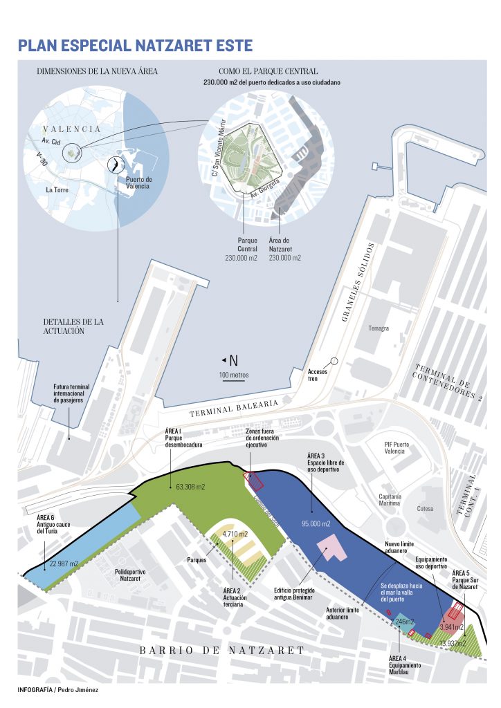
Area 3, sports facilities: 98,940.17 m2
Sports and free space area of 98,940.17 m2 extension. This sports equipment partially occupies the existing green zone to the south (Nazaret South park) and represents the recovery of the site of a sporting endowment, a green border between the port activity and the Natzaret district, and also a dynamic center of uses and activities linked to leisure and sports.
The planning orders this area, a priori, in two differentiated urban plots in order to facilitate its management and subsequent execution:
A first plot that occupies practically the entire area, with a floor area of 94,999.66 m2. The main destination will be to sports facilities in the open air. It provides the possibility of locating buildings linked to the main use, as well as other auxiliary constructions of support. In the plot of use ZV-DP (p3.1) is located the property protected by the general planning, “Benimar building, which is included in the Inventory of joint buildings and architectural interest elements of the city of Valencia. The planned sports equipment that includes this area must execute the rehabilitation works of the Benimar building.
The second plot has an area of 3,940 m2 to place covered sports equipment.
Area 4, Marblau equipment: 2,246 m2
The ordenation of the plan incorporates the existing equipment located on Algemesí street, currently in operation, managed by the City Council of Valencia through a concession for a youth center, popular university and Orchard Museum in the old Marblau spa. The surface destined to this area is 2,246 m2.
Area 5, South Natzaret Park: 8,375.86 m2
Area located on the southern edge of the surface, with an extension of 8,375.86 m2. The criteria applied for this area seek to overcome the perception of the final section and the neighborhood of Natzaret. The ordination proposes two independent green areas and separated by a road that from the Algemesí street runs parallel to the southern front of the covered sports facility to give access to a new parking area.
Green Corridor
The Naztaret Special Plan This includes a cyclist and pedestrian green corridor that connects the Mouth of the Park with the current corridor that, running through the Logistics Activities Zone, comes to connect with the Punta and Pinedo areas, with the objective of improving the continuity and dimensions of the green corridor that surrounds Nazaret by the northeast, linking all the maritime settlements from Malvarrosa to Punta and Pinedo. This bike lane will have a minimum width of 2.50 meters segregated from the road and the pedestrian area.