- Thousands of people have visited this exhibition, which takes visitors on a journey through the names of streets and squares in Valencia and its maritime neighbourhoods
- The exhibition is in the Clock Building and is free to visit until 9 November. Opening hours are from 11 a.m. to 7 p.m., Monday to Sunday
Valencia, 6 November 2025 – Valenciaport’s exhibition “El Marítim, a peu de carrer” (The Maritime District, at street level) is heading into its final weekend open to the public with a successful turnout. The exhibition, which takes visitors on a journey through the living memory of the ‘poblats de la mar’, Valencia’s seaside neighbourhoods, has received thousands of visitors since it opened to the public on 2 October.
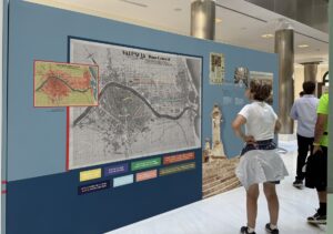
The Clock Building is hosting this exhibition, which will be open until 9 November from 11 a.m. to 7 p.m., Monday to Sunday. Admission is free and it is an opportunity to learn about different moments in the evolution of the port community and the city of Valencia itself through panels with text and historical images, which reflect part of this maritime and port history in its street map.
The names of streets and squares in Valencia are a vivid reflection of its past. In this case, the exhibition collects and highlights the history of some of the current place names linked to the city’s Maritime District, formed by the annexation at the end of the 19th century of neighbourhoods such as Malva-rosa, Poble Nou de la Mar, Cap de França, Cabanyal, Canyamelar, Vilanova del Grau and Natzaret.
Getting to know the neighbourhood’s origins
Visitors can learn about the origin of the name of neighbourhoods such as Cabanyal, which dates back to 1422 and is due to its characteristic fishermen’s huts and shacks. It also tells the story of the nearby neighbourhood of Natzaret, originally created to provide a secluded place for the quarantine of sailors and goods, although over time it dropped this function.
The exhibition also explains the maritime vestiges that still exist in the city centre, with places such as Calle del Mar, named because it was a direct route from the city centre to the sea, passing close to the old Customs House, and marking the exit to the outside world. The Porta de la Mar, meanwhile, was originally a gate in the medieval wall that connected the town centre directly to the port of Grao. The attempts, technical challenges and major projects that, from the 17th century to the second half of the 19th century, made it possible to transform a harbour with no natural shelter into a modern and safe infrastructure are also featured in this exhibition.