Locution
Key
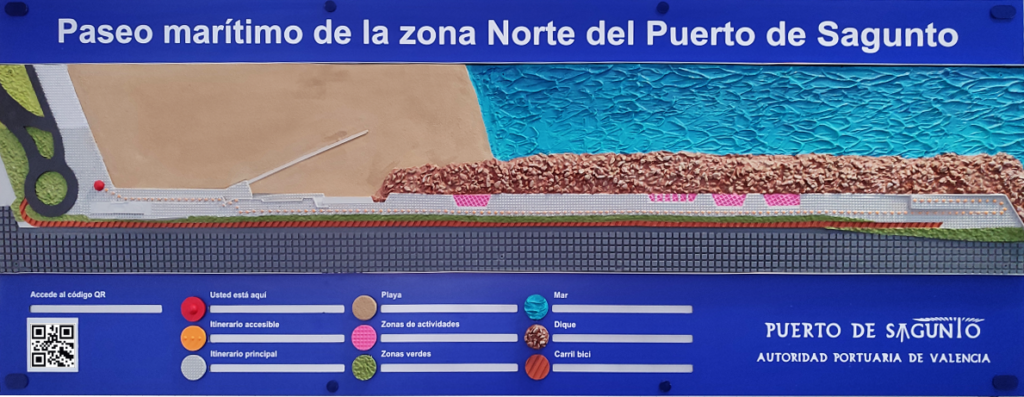

You are here. Red icon with bulging dome-shaped point.

Accessible itinerary. Orange icon with a line of small dots that simulate the route of the ride.
Main itinerary. Light gray icon with an array of small, evenly distributed dots.

Beach. Light brown icon with rough texture simulating sand.

Activity zones. Pink icon with ridges with shallow square shapes.

Parkland. Green icon with slight blunt ridges.

Sea. Blue icon with surface simulating wave crest.

Breakwater. Dark brown icon with ridges simulating stones accumulated on the floor.

Bike lane. Clay color icon with parallel and uniform line ridges.
Description
The new seafront promenade in the port of Sagunto, constructed by the Port Authority, is essentially built on the land formerly occupied by the mineral jetty of the Sierra Menera Mining Company and runs from the beach towards the sea for around 600 metres, attached to the north breakwater of the port of Sagunto. It is designed as a cultural, leisure and recreational centre for residents.
This promenade is the result of the various agreements and arrangements reached between the City Council and the Port Authority within the framework of port-city relations. With this initiative – which entails an investment of 5.5 million euros by the Port Authority – new spaces have been made available to the municipality provided for transition between the urban centre and the port activity.
Access to the new promenade is created naturally from the existing seafront promenade. The area in question is designed as a distribution area, generating multiple access possibilities:
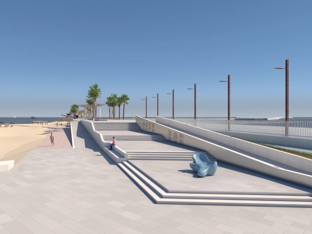
- 1: The main route, which takes pedestrians towards the access steps, creating an open and somewhat scenic effect, is emphasised by the gradual gain in altitude, rising to 5.60 m above sea level. This effect is created by three flights of stairs with limited number of steps interconnected by large landings, where there are aluminium panels with perforated texts narrating the origins of the port of Sagunto, the construction of the port and the railway and the development of the iron and steel industry. At the end of the stairway, the entire length of the promenade unfolds in front of the visitors. There, visitors can see the 28-metre-long mural displaying photographs of the Sierra Menera Mining Company’s installations from the early years of the 20th century.
- 2: This is an accessible route, with a 4% slope that allows access to the new promenade without the need to take the stairs.
- 3: A pedestrian route at beach level and in the direction of the sea leads to a passageway that gives access to a sports area – which has a small climbing wall, a calisthenics park and beach volleyball courts – and from which a wooden boardwalk begins, leading to the beach.
- 4º A cycle lane that begins at the roundabout behind us and runs at different levels along the promenade, along its right bank in the direction of the sea. At the end, it crosses the slope with the accessible path and goes to the bicycle parking area located at the end of the promenade. Along the route, the difference in level between the promenade and the cycle path is bridged with a slope, which is filled with different species of plants.
Going into the accessible route in more detail, it takes pedestrians to the ramp up to the promenade by means of a tactile pavement. Once they are at the start of the ramp, they will go up it, with a gradient of around 4%. This ramp has a banister on the left side going upwards and a concrete wall on the right side, which gradually decreases in height until it disappears as the ramp reaches the level of the main route. The ramp zigzags in its final stretch.
After the ascent, the walk is structured around clearly differentiated areas:
- 1. A transit and advance zone: this is a continuous strip of the accessible route, about 400 metres in length, is located on the right-hand side of the promenade, according to the direction of movement towards the sea. This area allows pedestrians to move along the promenade, is free of obstacles and has a small curb on the right-hand side, which serves as a guide and separates it from the one-metre-wide green area and the slope towards the cycle path. Between the end of the access ramp and this kerb, a tactile pavement has been installed to assist users to reach the kerb. At the end of this transit zone, this kerb changes its alignment, ceasing to fulfil its guiding functions and moves away from the accessible route until it disappears. In order to mark this point where the kerb alignment changes, a square of tactile button paving has been installed to warn users that the kerb is ending. From this tactile paving to the end of the promenade, there is a straight line of about 100 metres in length through a large sloping square that rises to 8.80 metres above sea level, with a cycle lane on the right-hand side, according to the direction of travel towards the sea.
- 2. A series of activity areas are constructed adjacent to the transit area along the promenade and are located between the promenade and the sea, offering panoramic views. These are areas used for various leisure activities listed below:
- A Grandstand overlooking the beach and sports areas
- A Playground area with seven different pieces of equipment, including a play tower and a climbing changing table.
- A Museum zone where an original hopper from the old mineral dock is located.
- A Large viewpoint at the end of the promenade, situated at a height of 8.80 metres above sea level, offering fantastic panoramic views. This viewpoint can be accessed from the main pathway through the aforementioned sloping square and is partially paved with wooden decking. The whole area is fenced by a handrail that provides protection from the unevenness of the surrounding terrain. It is worth noting that there are benches and lampposts on both the viewing platform and the sloping square. The walls which bridge the difference in level between the viewpoint and the sloping square contain photographic panels with images of the port from the middle of the 20th century as well as aerial photographs of the mineral jetty taken in 1977, the year it was put into service.
- Rest areas are arranged along the entire length of the promenade, lined with benches and palm trees.
Finally, the seafront promenade is remarkable for its impressive appearance, with a set of 7 shade pergolas, grouped in three sections of about 100 metres in length. These pergolas are spread over various levels between 7 and 11 metres in altitude and are made up of some 600 wooden slats, each 7.5 metres long and with a variable edge height. These slats are arranged perpendicular to the promenade’s axis and are attached to concrete beams that follow a meandering route and are supported by concrete piles, also of triangular section with chamfered edges. Nevertheless, in order to facilitate the understanding of the model, this set of pergolas has not been illustrated, except for the start of these piles, which can be found on the sides of the walkway and pedestrian area.